


Don’t Let One Problem Ruin Your Vacation
A few seconds now protects the trip you’ve already invested so much into.
Short Excerpt
- The Caribbean hurricane belt is a useful planning concept, but it does not describe the entire Caribbean with equal accuracy.
- Much of the northern and central Caribbean sits in more historically active hurricane corridors, while islands along the far southern edge of the region generally have lower direct hurricane exposure.
- Aruba, Bonaire, Curaçao, and Trinidad and Tobago are often treated as lower-exposure options because of their southern locations, although no island should be described as completely risk-free.
Quick Take
- The hurricane belt is not one sharp line on a map. It is a broad zone where historical storm exposure is generally higher.
- Puerto Rico, the Virgin Islands, the northern Lesser Antilles, the Bahamas, parts of Cuba, and the Cayman Islands sit in or near more active hurricane corridors.
- Aruba, Bonaire, Curaçao, and Trinidad and Tobago lie along the southern edge of the Caribbean and usually experience fewer direct hurricane impacts.
- The belt also shifts in practical importance during the season because storm formation zones change from early summer into fall.
- Luxury travelers should use the belt as a destination-selection tool, not as a guarantee that one island will be affected or protected.
The Caribbean Hurricane Belt Is Real, But It Is Not The Whole Caribbean
The phrase Caribbean hurricane belt gets repeated so often that many travelers start picturing a single clean boundary across the region.
That is not how Caribbean storm risk really works.
The hurricane belt is better understood as a broad zone of higher historical tropical cyclone exposure across much of the northern and central Caribbean and nearby Atlantic approaches.
It helps explain why some islands see more direct hurricane impacts over time, while others along the southern edge of the region are affected much less often.
This matters because the Caribbean is not one weather point.
A September trip to Curaçao does not carry the same historical hurricane exposure as a September trip to St. Martin.
A late-summer resort stay in Aruba is not equivalent to a late-summer sailing trip in the Virgin Islands just because both fall inside the official Atlantic hurricane season.
The belt is useful because it sets realistic expectations.
It reminds travelers that geography changes risk.

It also prevents the opposite mistake, which is assuming that a southern island is automatically outside all tropical-weather concerns.
Lower exposure is not the same as no exposure.
Nearby systems can still bring rain, surf, wind, flight delays, ferry problems, or excursion cancellations even when a direct hurricane strike remains unlikely.
What People Mean By The Geographic Hurricane Belt
When travelers or tourism sites refer to the Caribbean hurricane belt, they usually mean the portion of the basin most frequently affected by Atlantic tropical cyclones moving west across the ocean, curving through the northeastern Caribbean, or developing within the Caribbean itself.
That broad area includes much of the Bahamas, Puerto Rico, the Virgin Islands, the northern Lesser Antilles, Hispaniola, parts of Cuba, Jamaica, and the Cayman Islands.
These places do not all have identical risk.
What they share is greater historical exposure than islands on the far southern edge of the Caribbean.
Over many decades, storm tracks have crossed these northern and central zones much more often than islands such as Aruba or Curaçao.
This is why the hurricane belt should never be treated as a rigid cartographic border.
A better way to picture it is as a main storm corridor with heavier historical exposure in the north and center of the region, then lower exposure as you move farther south.
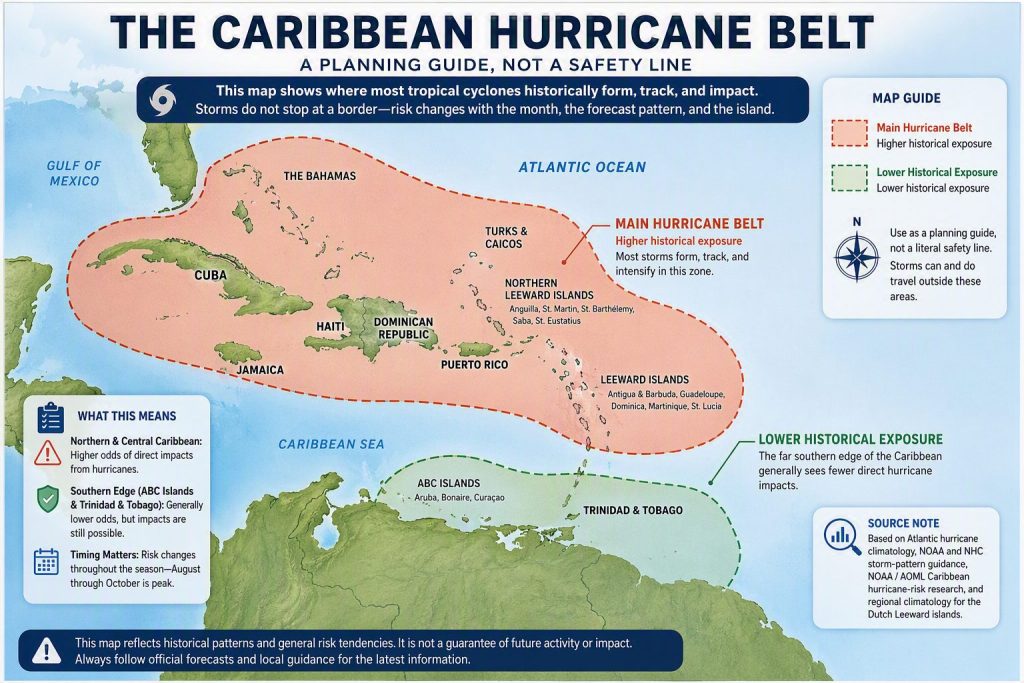
Hurricane Belt Map
This is the most useful place to see the concept visually because the map clarifies why some islands are discussed differently during hurricane season.
Out-Of-Belt Islands And The Southern Edge Of The Caribbean
The most commonly discussed out-of-belt or lower-exposure Caribbean destinations are Aruba, Bonaire, Curaçao, and Trinidad and Tobago.
These islands sit far enough south that they are outside many of the classic Atlantic hurricane tracks that affect the northeastern and central Caribbean.
That geography makes them especially attractive to travelers booking August, September, or October trips and looking for a more favorable historical storm profile.
Aruba is the best-known example.
Its location near the Venezuelan coast places it well south of the region most travelers picture when they think about the Caribbean hurricane belt.
Curaçao and Bonaire share that same general advantage, which is why the ABC islands are repeatedly recommended as lower-exposure hurricane-season options.
Trinidad and Tobago sit even farther south.
That can make them attractive from a storm-exposure standpoint, although the overall vacation style may feel different from what some travelers expect from a traditional luxury resort itinerary.
These islands should still be described carefully.
They are not hurricane-proof, and they are not immune to indirect effects from nearby tropical systems.
Strong swells, unstable marine conditions, rainfall, and transportation disruptions can still affect travel even when the islands avoid a direct hurricane impact.
Seasonal Shifts Change How The Belt Works
Another reason the hurricane belt is often misunderstood is that storm risk does not sit still through the season.
In June and early July, Atlantic tropical development is more often concentrated in the western part of the basin, including the western Caribbean, Gulf region, and nearby western Atlantic.
By August and September, the storm environment expands much farther east into the tropical Atlantic.
This is when long-track systems moving west from Africa become more relevant to the Lesser Antilles, Puerto Rico, and the northeastern Caribbean.
That shift helps explain why the northern and eastern islands receive so much attention during the core of hurricane season.
By October and November, the practical emphasis changes again.

The western Caribbean becomes increasingly important, which means destinations such as Jamaica, the Cayman Islands, Cuba, and parts of the western basin still deserve close attention even after the September climatological peak has passed.
So while the belt remains a helpful geographic concept, the most important risk zone of the moment can move during the season.
Travelers should think in two layers.
The first layer is geography. The second is the time of year.

Paradise Is Calling Your Name
Explore Sandals & Beaches deals
Why The Hurricane Belt Still Matters For Luxury Travelers
Some travelers hear all of this and conclude that the concept is too broad to be useful.
The opposite is true.
The belt matters because it improves decision-making before you book.
If you are planning a honeymoon, a destination wedding, a milestone birthday trip, or an expensive family resort stay during late August, September, or October, geography deserves more weight than it would during the winter or spring.
That does not mean every traveler should automatically choose Aruba or Curaçao.
A traveler who strongly prefers St. Barts, Anguilla, Puerto Rico, or the Bahamas may reasonably accept greater historical storm exposure because the destination itself is the priority.
The value of the hurricane belt is that it helps you understand what tradeoff you are making.
It also helps shape smarter booking behavior.
A higher-exposure island may still be completely worth booking if the resort has a strong hurricane policy, the flights are flexible, and the financial risk is manageable.
A lower-exposure island may still deserve caution if the trip involves complicated air connections, nonrefundable payments, or a very tight travel schedule.
The Hurricane Belt Does Not Predict Your Exact Vacation
One of the biggest misconceptions is that an island inside the hurricane belt is likely to be hit during any given trip.
That is not how historical exposure works.
The belt describes broad patterns over time, not a forecast for your exact dates.

A higher-exposure destination can go through a full season untouched.
A lower-exposure destination can still experience indirect weather disruptions.
A storm might affect flights to an island without producing dangerous local conditions at the resort itself.
This is why the belt should be paired with other planning tools.
Use it to narrow destinations.
Then evaluate the resort’s storm policy, look at how refundable the reservation is, consider travel insurance for expensive prepaid costs, and switch to official forecasts as departure approaches.
A Smarter Way To Use The Map When Choosing An Island
The most practical way to use the hurricane belt map is to ask four questions.
Where is the island located relative to the main storm corridor?
What month am I traveling?
How expensive and nonrefundable is this trip?
How easily can I change plans if the forecast worsens?
That approach turns the map into something useful.
A southern island may offer a better historical profile, but the final decision still depends on your destination preferences and flexibility.
A northern island may be the right choice anyway if it offers the exact experience you want and the booking terms support smarter hurricane-season travel.
The goal is not to fear the map.
It is to use it honestly.
Practical Takeaways For Understanding The Caribbean Hurricane Belt
- The hurricane belt is a broad higher-exposure zone, not a precise line.
- Much of the northern and central Caribbean sits inside or near the main historical storm corridor.
- Aruba, Bonaire, Curaçao, and Trinidad and Tobago are among the best-known lower-exposure southern islands.
- Lower exposure does not mean zero disruption risk. Nearby storms can still affect travel conditions.
- Seasonal timing matters as much as geography. August through October deserves the most attention, while practical risk zones shift during the season.
- Use the belt to compare islands, not to predict exact outcomes.
- Booking flexibility, resort policies, and travel insurance still matter after you choose the destination.
The most helpful way to think about the Caribbean hurricane belt is this: it explains where storms are more likely to matter over time, not what your exact vacation will look like.
That makes it a valuable expectation-setting tool.
You do not need to treat the entire Caribbean as one uniform risk zone, and you do not need to assume that a southern island is completely protected.
A more accurate map leads to better travel decisions.
Escape the Chaos. Upgrade to Paradise.
See today’s exclusive offers

FAQ – What Should Travelers Know About the Caribbean Hurricane Belt?
What Is the Caribbean Hurricane Belt?
The Caribbean hurricane belt is a broad zone of higher historical tropical cyclone exposure across much of the northern and central Caribbean.
It helps explain why some islands see more direct hurricane impacts over time than others farther south.
The phrase describes a pattern, not a perfect line on a map.
Travelers should treat it as a planning concept rather than a precise boundary.Does The Hurricane Belt Cover the Entire Caribbean?
No. The whole region is not equally exposed to hurricanes.
Much of the northern and central Caribbean sits in more active storm corridors, while islands along the far southern edge generally experience fewer direct impacts.
That is why Aruba and Curaçao are often discussed differently from Puerto Rico or the Virgin Islands during hurricane season.Which Islands Are Commonly Considered Outside or on the Edge of the Hurricane Belt?
Aruba, Bonaire, Curaçao, and Trinidad and Tobago are the most commonly cited lower-exposure southern islands.
Their locations place them outside many of the classic Atlantic hurricane tracks that affect the northern and central Caribbean.
That makes them appealing to travelers booking late-summer or early-fall trips.
They should still not be described as completely risk-free.Why Are Puerto Rico, The Virgin Islands, and the Northern Lesser Antilles Discussed as More Exposed?
These destinations sit closer to major Atlantic storm corridors that become especially relevant during the core of hurricane season.
Long-track systems moving west across the Atlantic can approach the northeastern Caribbean during August and September.
That gives the region greater historical exposure than islands on the southern edge of the basin.
Travelers visiting these areas should place more value on flexibility and resort policy details.Does Being Outside the Hurricane Belt Mean My Vacation Cannot Be Disrupted?
No. A lower-exposure island can still experience rough seas, rain bands, wind, flight delays, or excursion cancellations from a nearby tropical system.
Direct hurricane exposure and trip-disruption risk are not exactly the same thing.
The hurricane belt helps you compare long-term storm patterns, but it does not eliminate the need for practical travel planning.
Flexible reservations still matter.How Does the Hurricane Belt Change During the Season?
The geography of the basin stays the same, but the most important storm formation zones shift as the season progresses.
Early in the season, activity is more often concentrated in the western part of the basin.
By August and September, the eastern and central tropical Atlantic become much more relevant to the northeastern Caribbean.
Later in October and November, the western Caribbean becomes especially important again.Is September Always a Bad Time to Visit the Caribbean If an Island Is Inside the Hurricane Belt?
Not always. September is the climatological peak of the Atlantic hurricane season, so the timing deserves respect.
Even so, an island inside the hurricane belt is not guaranteed to be hit during your trip.
Many travelers still go successfully during this period, especially when they understand the exposure and book with flexibility.How Should Luxury Travelers Use a Hurricane Belt Map?
Use the map as a destination-selection tool first.
It helps you compare islands by historical exposure and choose whether a southern or northern destination fits your risk tolerance better.
After that, look at the resort’s hurricane policy, flight flexibility, and the financial risk of nonrefundable bookings.
The map works best when it is combined with booking strategy.Is The Hurricane Belt More Important Than Resort Quality or Price?
That depends on when you are traveling and how much uncertainty you are willing to accept.
During peak hurricane months, geography deserves more weight because it changes historical storm exposure.
A resort can still be the right choice inside a higher-exposure zone if the experience is worth it and the booking terms are strong.
The best decision balances destination appeal with practical flexibility.What Is the Biggest Mistake Travelers Make When Thinking About the Hurricane Belt?
The biggest mistake is treating the Caribbean as one uniform storm zone.
The second biggest mistake is assuming that a lower-exposure island is completely protected.
Both views flatten a much more nuanced map.
Better travel planning starts when you recognize that geography matters, timing matters, and flexibility matters too.